This power grab, masquerading as a feel-good, all-American recreation program, comes on top of a separate, property-usurping initiative exposed by GOP Rep. Robert Bishop and Sen. Jim DeMint earlier this spring. According to an internal, 21-page Obama administration memo, 17 energy-rich areas in 11 states have been targeted as potential federal “monuments.” The lives of coyotes, deer and prairie dogs would be elevated above states’ needs to generate jobs, tourism business and energy solutions.
Take my home state of Colorado. The Obama administration is considering locking up some 380,000 acres of Bureau of Land Management land and private land in Colorado under the 1906 Antiquities Act. The Vermillion Basin and the Alpine Triangle would be shut off to mining, hunting, grazing, oil and gas development and recreational activities. Alan Foutz, president of the Colorado Farm Bureau, blasted the administration’s meddling: “Deer and elk populations are thriving, and we in Colorado don’t need help from the federal government in order to manage them effectively.”
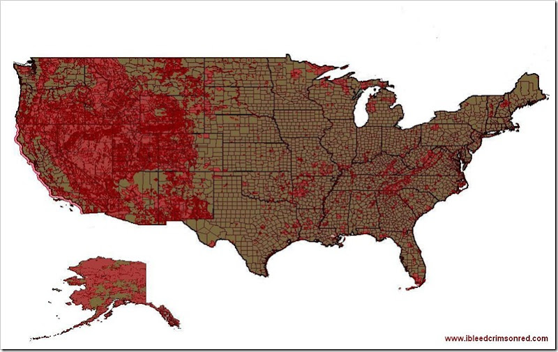
It’s not like the government doesn’t already own or control a lot of the land in the continental United States. The map below, generated by my MapWindow GIS application, shows the areas owned or controlled by the United States goverment. It includes national parks, wildlife refuges, monuments, military reservations, everything. The area shown in red represents federal ownership.
The new initiative Michelle is warning about would add even more land to the federal portfolio, including some of the most mineral rich places in the country. It’s nothing more than a continued assault on private property rights and a march against the ability of the American people to enjoy the fruits of this great country, for our individual satisfaction, profit and mutual benefit.
Here is the citation and abstract from the metadata file accompanying the shapefile defining the federal lands map layer:
Citation:
Citation_Information:
Originator: National Atlas of the United States
Publication_Date: 200512
Title: Federal Lands of the United States
Publication_Information:
Publication_Place: Reston, VA
Publisher: National Atlas of the United States
Online_Linkage: http://nationalatlas.gov/atlasftp.html
Description:
Abstract:
This map layer consists of federally owned or administered lands of the United States, Puerto Rico, and the U.S. Virgin Islands. Only areas of 640 acres or more are included. There may be private inholdings within the boundaries of Federal lands in this map layer. This is a revised version of the January 2005 map layer.
I can make the shapefile available for anyone interested in it, but you must have mapping software to use it.
Gimme some feedback in the comments.


0 comments :
Post a Comment
You must have a Google Account to post a comment.
WARNING: Posting on this blog is a privilege. You have no First Amendment rights here. I am the sole, supreme and benevolent dictator. This blog commenting system also has a patented Dumbass Detector. Don't set it off.